
Asking, talking, and showing genuine interest in a place bring us to some really unexpected beautiful places. Such is the case in the island of Godoya. It was not in our itinerary, nor ever heard of it before; yet we stayed here for four quiet relaxed days. We came to know about this place through the Tourist employee when we asked about places to visit in Alesund. We became so interested that we drove to this place right after Alesund.
DRIVE TO GODOYA
Godoya is one of the small islands that belong to Giske community, still part of Alesund. The other islands are Vigra, Valderoya and Giske. Godoya lies at the end. The drive was pretty exciting and special as we had pass 3 toll-free sub-sea tunnels, one land tunnel and another bridge to get to this island. The sub-sea tunnel from Alesund to Ellingsoy is 3500 meters long, from Ellingsoy to Valderoya is 4200 meters long; depth is about 140 meters below sea level. The sub-sea tunnel from Giske to Godoya is 3850 meters long, about 155 meters below sea level. It surprised us that these tunnels are toll-free, as compared to the many toll roads we had in Karmoy island. As I have mentioned earlier, the drive was pretty exciting and unusual. In about 30 minutes, from Alesund, we reached the last island, Godoya. The last tunnel was pretty different, as it was a bit narrow and could only accommodate one vehicle at a time. There are wider places at some points where the other vehicle can wait. Driving thru the three islands, we could immediately feel the calm and quietness, which we frankly missed for the last weeks. Upon reaching Godoya, we followed the mark for parking for the lighthouse (Alnes Fyr). And just in front of the lighthouse, by the sea, we found a perfect spot to camp. We even had a barbecue and dinner at the pebbled area on our first day. We stayed in Godoya from July 22-24, 2015.
Campsite : Parking, Alnes Fyr
6055 Giske (More og Romsdal)
Coordinates : N : 62.49128 E : 5.96716
")
")
It was a perfect campsite for us in a way that we were just a few meters away from the sea and from the lighthouse; a short walking distance to the starting point for the hike and for fishing. Hans made a stone pathway in going down to the pebbled area in our beachfront, so we didn’t have to walk around the road. Good he! It was also a perfect place to see the stunning sunset, when it was there !
DRAMATIC HIKE TO MT. GODOYA
Browsing to the information leaflet we received from the tourist information, we saw that there are possibilities for a good hike in Godoya. And that is hiking to Mt. Godoya, whose highest peak is 497 meters above sea level. There are three possible starting points : at school, from the lighthouse, or from Gjuv, at the other side of the island. From where we camped, we could see the top of the mountain. And it looked like a good easy one for us. But knowing us, we have acquired the habit of going for a difficult one; so we decided to follow the long route which runs along the coast going to Gjuv, then up to the mountain, and down to the light house. The hike was categorized as Challenging, and it was, indeed! What seemed to be just a 4- hour hike became almost 8 hours! We were very tired at the end of the hike; but contended and proud.

The hiking map
First Leg of the Hike
We began our hike at 10.30 in the morning, after looking what the weather would be like. It was a bit cloudy but dry. From the camping area, we followed the road, then took the dirt path on the side going to the beach area. From there, there is a path that logically goes to the foot of the mountain by the beach. There were no red marks; the trail was not marked; we only knew we had to follow the coastline, and so we did. After about 40 minutes of walking, the red-painted marks appeared.
")
")
")
")
From then on, we followed these marks. The walk along the coast was magnificent. We had to walk rocks/ big stones. We had the most wonderful views of the ocean, the innumerable wonderful rock formations and the mountains around us. The rock formations reminded us of the Flysch formation in Zumaia, Spain which were very special formations created thru millions of years of interaction between the rocks/stones and the sea. We made a lot of stops here because the views were simply amazing! Indescribable! The pictures we took could not give justice to the beauty we were seeing! It was fun looking for the nice oval- shaped stones and construct stone man out of them. We had our coffee break in one of the flat rock beds we found, and after that we continued on. Along the way, we had to climb and get down from rocks, using chains which were placed at dangerous points. We had to be very careful, as one wrong step would mean broken arm, leg or ankles, or worst, great injury!
")
")
")
")
")
Thankfully, we survived all these challenges! At one point, at Lesten, there is a big plastic capsule where we could write our names! We had this amazing difficult hike for about 3 hours, before we finally reached Gjuv. I was able to ask for a bottle of water from a resident here. That was the end of our first leg of hike.
Second Leg of the Hike
Now on to the second leg: from Gjuv up to Storehornet. Storehornet, which is 497 m high , is the highest peak of Godoya mountain . It was 15.30 when we started our hike from Gjuv. There were no red marks here; just follow your common sense: cross the street, go in the street opposite, follow it thru the mountains. The begin was immediately steep, but the path was well-made, of good-arranged stones. Sometimes we had to avoid some muddy areas, which was still doable at this point. Getting higher, we had a nice view of the sea and the village under us. As we got higher, the path was becoming more difficult, wetter and muddier. After a good 0ne hour, we reached the Lake Alnes. Again, there was big capsule here in which we entered our names!
")
")
")
")
From here, we could choose to go to Storehornet, or just go around the lake and down to Alnes. Going to Storehornet was our plan, so we turned right. We could already see how high we still had to climb. We pursued our task. The hike to the top took another hour. The path was steep, stony, wet, and it was chilly. There was hard wind because we were again so high. We would see the whole lake below us. We had to climb again here using chains fro a couple of times, but we were getting used to it at this point in our hike. How higher we got, how more amazing the views we were getting! There was the magnificent views of the sea, mountains, the fjords, and even Alesund! Extra ordinarily beautiful. The most beautiful sight Hans and I have ever had in our hikes! Finally we reached the top : the Storehornet! The view is simply amazing! What more can I say??? We just stood there for few minutes, admiring the views, and taking some pictures; both speechless! There were two stone pillars on top; one has a kind of metal compass on top of it, with the mountain peaks around the area. There are two notebooks where we wrote our names in it!
")
")
")
")
We could see the thin clouds just passing us by, or was it the mist? With the hard gush of the wind, the thick clouds coming from the sea was covering the whole mountain area in less than five minutes. In no time, there was literally zero-visibility. Gone were the wonderful views before us! All we saw was thick clouds covering the sky! Fortunately, we could still see the path, so we decided to climb down back to the lighthouse. It was not a good path; full of mud and illogical ways. We just had to look ahead of us and see where we were heading. The fog was also gradually disappearing, until it was completely gone.
")
")
Surprisingly, we saw still a lot of people going up to the lake at this time, around 6 pm. We were not so careful anymore about the wet areas and mud, as our shoes were already wet and dirty. Following the dirt path going down, we could see Alnes before us. It took us another 1.5 hour to reach the bottom. It was 19.30 when we finally reached the camper, tired physically, but feeling rewarded! It was a hike we would like to do again, especially the first three hours.
LAZY DAY AND FISHING TIME
The next day, still suffering from some muscle pains from the tedious hike from the last day, we decided to take it easy. The morning was spent in just strolling and taking pictures around the Alnes light house, and taking a walk at the pebbled beach and checking if my stonemen were still standing! We were planning to go fishing, but we had to wait until afternoon for that as it rained again! So we were obliged to stay in the camper, did some photo works and reading.
")
")
Early in the afternoon, when the rain has stopped, we got our fishing gears and headed to the pier. Surprisingly, we saw crabs crawling in the water just near the pier. Hans tried to catch crabs, using his fishing rod, and it worked! In no time, he had 3 big crabs! Amazing! I was really happy! However, the fourth crab was difficult to catch; seemed like the crabs were wiser or not hungry at all. We then proceeded with our plan to go fishing. I caught 3 normally-sized fishes; I had to throw 2 back in the water as they were not big enough L Hans had no bait at all J That’s when we went back to crab fishing and was able to catch the fourth one. Our lazy day proved to be a productive one also…we have food for the next day.
We left Godoya the next day and headed to Giske. We drove around Giske, but found it not so exciting a place as Godoya. Further, we drove to the island of Valderoya, to the parking and starting point to the hike to Mt.Valderoy (Signalen). The parking was not so appealing, so we decided to head back to Godoya and made it as our campbase for the next 2 more days. We then parked at the parking of a small boat harbour, just near the Godoya tunnels. It was a very good place for fishing, as Hans caught a very big Pollock, about 3 kilos, 65 cm long, and many other fish, 14 pieces in total, more than enough fish supply for us for the next week!
")
")
")
")
")
")
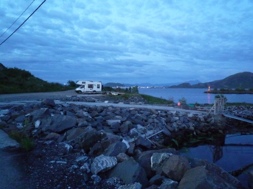
Campsite : Parking, boat haven
6055 Godoya
Coordinates : N: 62.48433 E: 6.04410
Godoya is a special place for us : we have experienced here the tranquillity which we missed for quite a time, we had one of our most beautiful hikes here, first time to go crab fishing, first time to see a good sunset after 7 weeks in Norway, and to top it all, in our last night, the rainbow appeared in the sky! I have even saw one of the first good sunsets I have here in Norway! More special than that doesn’t exist!
")
")
Our customary picture together 🙂
