
Coming from Andalsnes, we set forth our journey down to Road 63, The Geiranger National Tourist Route, hoping to end up in the famous village of Geiranger. On the way, we made two major stops : in Valldal and in Eidsdal. From Valldal, we planned to take a side trip to Tafjord, a small village left of Valldal. But to go there, we had to drive into a tunnel which has a maximum height of 3.1 meters. Our camper is a little lower than 3 meters, but we didn’t want to take the risk of maybe being trapped somewhere inside the tunnel, so we blasted that plan again, and opted instead to drive to Eidsdal, which proved not to be a wrong decision after all. Unluckily we had bad weather conditions during these days, as it rained almost everyday and every night. But we didn’t let that dampen our spirits!
VALLDAL, STRAWBERRY FIELDS FOREVER
Valldal is located about 30 kilometers from Trollstigen. It is famous for its numerous strawberry fields, and it is said that many people go here to work as strawberry pickers during the season. It was a bit foggy when we left Trollstigen and headed for this valley. True, we saw lots of strawberry fields along the road, and many pickers at work. We found a campsite by the Parking at Tourist Info Office, by the boat harbour. Internet code can be obtained from the Tourist office, next to it is a fastfood, with at the back side, toilet for 10 NOK per use, and possibilities for showers, laundry and drying for 10 NOK each per use. We stayed here for two days from July 30-31, 2015. For a quieter stay, one could also camp at the strand promenade along the Norddalsfjorden, which some campers also did.
Campsite : Mix-Parking, Tourist Information/Boat harbour
6210 Valldal
Coordinates : N : 62.29782 E: 7.26016
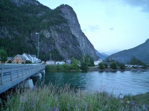
Valldal is like a big camping village. There are a number of huge campings along the way and along the river banks. And they are also full, including mobile homes! From the map we obtained from the tourist office, Hans and I decided to just make an easy stroll around the village; no exciting one. So we chose what seemed to be the easiest hike, which was described in the pamphlet as an easy walk and would take us 3 hours, round trip. Yes, the start was easy, just a normal stroll along the river banks. The path was wide and nice to walk on. We passed a big strawberry field and ripe strawberries were just waiting to be picked. In fact, there was a sweet strawberry smell in the air!
")
")
")
Hhhmmm…We just followed the river. Along the way, we saw from a distance a nice rather high waterfalls. Upon looking closely, we saw that there were people at work up there and there was a bridge; so we thought, we could go there. Asking for direction from somebody, we learned of a way to go up. It was in the woods, with very steep climb and narrow path which seemed not to have been used for a long time. We continued climbing up, missing the falls and bridge at one point, so we had to descend a bit, until we came to a small clearing, where we had a wonderful close up view of the waterfalls and the village of Valldal and the fjord. We stayed there for quite some time, admiring the views and observing the workers do their work in the forest.
")
")
")
After a while, we descended again, and tried to continue our interrupted stroll around the village. But after passing a big camping, we lost the path of the trail and could see no marks or indicator where to head next. Feeling irritated and tired, we just decided to go back the same way to the campsite, and just had a quiet day. There we strolled along the promenade, and did the laundry. I tried later in the evening to catch some fish at the fjord; but no success. Which was also good, as the night before,, we had already caught 6 pieces. Though the temptation to fish and to catch at least one salmon are great. When? We don’t know .
KILSTI HIKE IN EIDSDAL
After a couple of quiet days in Valldal, and disappointed that we couldn’t go to Tafjord and do some nice hikes there, we opted to drive through to Eidsdal, which is located just at the other side of the Norddalsfjorden. We took the ferry for 99 NOK and arrived in Eidsdal, together with some heavy rain. Having coffee by the ferry terminal while waiting for the rain to stop, we planned our next hike : the Kilsti-Blahornet hike in Eidsdal. It was 12.00 when the rain stopped, so we immediately drove to Kilsti, which is about 4 kilometers from Rd 63. The road was narrow and we were driving at really high grounds, so high that I wanted to back out. It was at the height of 500 meters that we arrived at the Parking Gjerdeneset along the Kilsti road, which is also the start of the hikes. We stayed the night here also; and stayed for the next couple of days from August 1-2, 2015.
Campsite : Kilsti/Gjerdeneset
6215 Kilsti (More og Romsdal)
Coordinates : N: 62.25291 E: 7.14532

DOING THE KILSTI-VERPESDALEN-FLANA-BLAHORNET HIKE
There are several hikes that could start from the parking area, from easy to difficult ones. The most famous is the hike to Blahornet, with the antennae and good view of the fjord, combined with round hike to the lake. But it seemed too easy for us, so we opted for a more challenging one, which was really long and tiring! The hike we chose took us 7 hours to complete!
It was 12.30 when we started. The begin was really easy, just like having a stroll in the forest, straight walking with some cases of easy balancing, avoiding stones and muddy areas. After about 20 minutes, we reached the Kilsti lake. At this point, we saw several hikers also, but have seen no one till the later part of the hike. Because we were doing Verpesdalen hike, we stayed on the left side, walking along the lake. It was then that it started to rain, so we had to use our raincoat.
")
")
")
Arriving at the Kilstisetra/farm, we put our names on the name registry found in one of the old farmhouses. There were about 5 old closed farmhouses situated at this part of the area, surrounding the lake. We then took a very steep climb going to Verpesdalssetra/farm. The higher we got, the nicer views we had from the Kilsti lake and farm. We hiked thru narrow wet pathways, into deep vegetated part of the forest, until, after one hour, we reached a high part with no trees anymore. The rain was on and off at this point. It was also a bit chilly. There was a fallen signboard, one pointing to Verpesdalssetra, the other to Grotet. Following the way to Verpesdalen, we got higher and higher, and obtained wonderful views of the Storfjorden and Norddalsfjorden and the town of Stranda. We also noticed that we were now really far from Blahornet and wondered how we could arrive there???
")
")
")
")
")
After arriving at the highest point of this hike, we had to climb down the valley again. It was a difficult descent, as it was steep, wet and muddy! But we managed it quite good! We followed the red painted marks which were surprisingly present all thru the hike even in the deepest part of the forest. The trail led us to Verpesdalsetra, where we found three old wooden houses. One of the old houses was luckily open, and we were able to take a look inside of it. It looked like we were in the 1960s. There were things from those years found inside the hut, like old transistor radio, matches, kettle, old style heater and cooker, some plates and saucers, old bed and sheets, where one can go in time of emergency.
")
")
")
")
After this delightful discovery, we continued our hike. We were now three hours on the way. We walked on narrow, wet and grassy and thick forested area. Avoiding wet areas had no use anymore, as our shoes were already wet! There were lots of ferns and wild blueberries along the path. After another hour, we reached Verpesdalen. There was a big house there, with a very old barn. We stayed here for a bit to rest. There was a choice of going to Kilsti back or to Flana. We chose Flana, and started to climb again in a very steep area. It was really tiring, but we had to move on and hurry as it was already getting late. Every now and then. We had views of the fjords, but we didn’t have lots of time to make long stops. At last , at 5 pm, we reached Flana. Here we had wonderful views of the fjords and Stranda, and Valldal in the distance. We could also see the Blahornet again, and the mountain that we still had to climb.
")
")
")
")
")
")
From Flana, the climb to Blahornet was difficult. In fact it was the most difficult part of the hike! We really had to be very careful as we had to cling or hold on to some branches of trees and sometimes on the rocks to be able to climb. It was really nervous-wrecking. But Thank God, we did it! We were then wondering why the hike from Flana to Blahornet was categorized as Moderate. It is in fact Challenging, for us! From Blahornet, which is 742 meters high, we had the most wonderful views of the two fjords, Storfjorden and Norddalsfjorden, and also Valldal and Stranda, and the mountains that we have climbed earlier that day! All our tiredness seemed to disappear, upon reaching this last difficult part of the hike! It was 18.10 when we arrived here. We did not stay here for so long, as it was getting late and getting cold. After admiring the views and some picture taking, we started our descent, which only took us an hour to do. After hiking for 6 hours, we didn’t come across a single hiker, and here on our climb down, at the last 7th hour, we saw 4 other Dutch hikers who wanted to do the small hike.
")
")
")
")
It was 19.10 when we returned back to the camper. Only our camper and the Dutch car stood there. We were really tired, but proud of what we have achieved that day! The weather was not so good, but we didn’t allow that to stop us from doing what we planned to do that day! We had a quick meal after that, and went to rest our tired aching bodies earlier than we used to.

Our customary picture together 🙂
