The Parque Natural Sierra de Grazalema is located between the provinces of Malaga and Cadiz and covers 51,695 hectares . Because of its special mountain characteristics and the abundance of special species of flora and fauna in the area, the park is declared as part of Biosphere Reserve by the UNESCO. It means that it is a protected zone both in terrestrial and coastal setting and is a representative of the harmonious relationship between man and nature. Driving through the park area is an incomparable adventure in itself. We drove thru long and winding roads, which continuously went uphill and downhill, passing amazing landscapes, deep valleys, high rising and endless mountain ranges and charming pueblos blanco or white mountain villages.
Among the white villages we have visited were Grazalema, El Bosque and Ubrique. We have combined our visits with a number of hikes which were available in the villages. In so doing, we were able to see more of the natural beauty of the surrounding.
PUEBLOS BLANCO
There are a lot of white villages that are found in and around the park. Because of limited time, we were able to visit only three of them : Grazalema, El Bosque, and Ubrique.
1. GRAZALEMA
It is impossible not to fall in love with Grazalema. The town, which has a compact urban lay-out and romantically situated between the mountains of Sierra del Endrinal and Sierra del Pinar, has a charming and friendly atmosphere. It has a typical Arabic charateristics such as the narrow streets, gable roofs, and white washed houses and walls. It is also unbelievably clean, which we rather didn’t expect in a Spanish village. Except for a few cigarette butts scattered in the streets in the outer part of the town, we had further nothing to complain of.
The white houses have small windows protected with steel trallies and adorned with flowering plants. There are a number of miradors or viewpoints where one can have a wonderful view of the whole town. These are : El Santo, El Tajo, Los Asemaderos, Los Peniscos and Presa Fresnillo. We had the best view at Mirador El Santo, where you can also find the stone statue of Jesus, and if you walked further, you’ll find an abandoned Ermita del Calvario.
")
")
")
")
There are four major churches in town : Iglesia de San Jose, Iglesia de San Juan, Iglesia dela Encarnacion, and Iglesia dela Aurora. A charming plaza is located in front of Iglesia dela Aurora, on the principal road to El Bosque.
")
")
What made the town even more charming and interesting is the presence of information boards located at some points, giving the tourists extra information and deeper knowledge in the history, culture and gastronomy of the town. Two of the interesting stories was about the bandit Jose Maria El Tempranillo and the history of the Roped Bull from Grazalema.
")
")
")
HIKING THE SIERRA DEL ENDRINAL
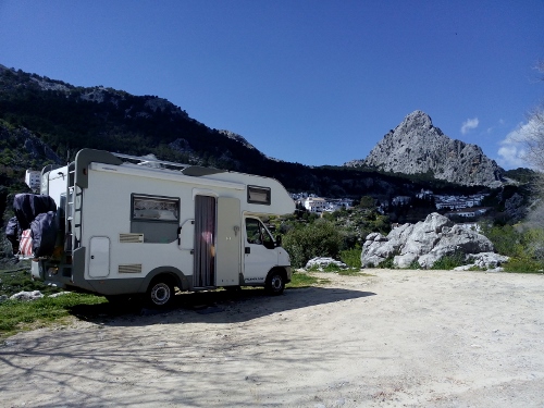
The major hike which we did in Grazalema was the hike to Sierra del Endrinal. This is an 8-km circular hike with medium difficulty that begins at Camping Tajo Rodilo and passing thru Llano del Endrinal (1200 m) , Puerto delas Presillas, Mirador Puerto del Boyar (1103 m) and finally walking down the easy Camino de los Charcones back to the starting point.
")
")
")
")
It took us four hours to complete the hike. It was a bit tiring, but rewarding. The path was a combination of compact ground and stones. We passed thru wonderful landscapes, high in the mountains. The characteristic was similar to El Torcal, with its big limestone rocks and karst formations. There were a number of good look out points where we could really see the immensity of the mountains as far as we could.
")
")
")
")
Another hike which we did, but a lot shorter than the first one, was an hour hike to Presa del Fresnillo. It was a hike which begins at Plaza Asamblea which passes thru steep rocky edge of the mountain, going up to the water reservoir. We had to ascend the metal stairs in going up to the reservoir. It is where the rainwater is kept and distributed to the town of Grazalema and nearby villages during dry periods.
")
")
2. EL BOSQUE
After spending two wonderful days in Grazalema, we drove to El Bosque. We drove a distance of 20 kilometers to reach the village, driving thru a very exciting mountain road with wonderful landscapes and stunning views. El Bosque is another white village in the park, a lot smaller than Grazalema and the lay-out is more scattered. There is a charming plaza infront of the Ayuntamiento, near the church, where children played ball. We stayed here for only one day, enough to see the whole village and do a short hike.
DOING THE RIO MAJACEITE TRAIL
One of the major activities in the area is walking along the Rio Majaceite. This is an easy 4.3-km linear hike from El Bosque to the next village Benamahona, passing thru the nice river of Majaceite. We combined this hike with a visit to the Botanical garden which is located near the river. The Garden houses many species of flowers specifically mountain orchids, herbal plants and lots of Pinsapar. It is also a home to lots of birds (according to the folder and information board that we have read) , but unfortunately, we only heard them chirping. We did however saw a big lizard with quite a long tail.
")
")
")
")
")
")
")
")
From the garden, we followed the Sendero path to Rio Majaceite. It was a busy path; many people were walking the trail, enjoying the nice weather and wonderful surroundings. There is a clear trail along the river; sometimes we had to passed narrow bridges made of wood and steel. The water was clean and gave a kind of refreshing effect to the hikers. The water of the river is also a good breeding site for trouts, and supplies the two fish factories in the area. The place near the river is also a popular hangout for Spaniards to do some picknicking and meeting up with family and friends.
")
")
")
")
")
")
")
")
")
3. UBRIQUE
After El Bosque, we decided to drive to Ubrique, which is located 16 kilometers south of El Bosque. Ubrique, which lies 337 meters above sea level, is located between two important natural parks in Andalucia : Sierra de Grazalema and Los Alcornocales. It is embraced by the mountain with same same, Sierra de Ubrique. Ubrique is almost synonymous to leather. There are lots of leather factories and shops which sell the finished leather products.
It was raining when we arrived in Ubrique, and also raining when we departed. Fortunately, we had a few dry hours which we wisely spent in exploring the town’s casco antiguo or historic center. Common to towns with Arabic influence, Ubrique’s historic center has long, winding and narrow streets and alleys, sometimes it made us wonder how the cars still could drive here. But we see also lots of cars here with crashes on both sides. The houses were traditional two-story with charming steel balcons.
")
")
")
")
")
")
The streets in going up to the miradors are just fascinating : they are like snakes trying to find their way out, and the houses were built in such a way that they were adapted to the street situation (or was it the other way round?). Anyway, beautiful flowering plants of carnation, geraniums and zenias adorned the front yards of these white houses. During our brief stay in town, we were able to visit three of the miradors : Mirador San Antonio (which can be reached by entering the Ermita de San Antonio), Mirador Ubrique Alto and Mirador Ermita Del Calvario (walking up the stairs up to the small church). All of theses viewpoints gave us stunning panoramic views of the town. It was just a bit unfortunate that the sky then was covered with gray layer of clouds.
")
")
")
")
FAILED HIKE TO LA CALZADA ROMANA
After our short tour of the old town, we were back in the camper, just in time before the heavy rain fell. We waited about an hour, and when the rain stopped, we then prepared ourselves to do a short 3.4-km linear hike to Calzada Romana, the trail which begins near our parking area and ends at the next small village of Benaocaz. We were however not able to complete the hike, as it started to rain again. After walking at least 2.5 km, we decided to blast it off and return to the camper. We were not sorry to do this, as we found the trail a bit boring. In the beginning, there was nice a nice view, but it stayed the same for the next 2 kilometers. There was no variation. We were just keeping on going up and up. And still no sight of the supposed to be old castle or Roman ruins. And the road was stony/rocky that we had to be very careful especially on our way back when it was raining and the stones were a bit slippery. That was our failed hike to Calzada Romana.
")
")
")
")
")
")
CAMPSITES :
- Grazalema : A-372 11610 Grazalema
Coordinates : N: 36.76205 W: 5.36228
This is opposite the Ermita Nuestra Senora delos Angeles, with stunning view of the town.
2. El Bosque : Carretera del Bosque a Ubrique
11670 El Bosque
Coordinates : N: 36.75881 W: 5.50951
It is an enclosed vacant lot with a huge pavilion in the center, behind the Hotel Truchas. Services for campers are available near the parking at Bull Ring.

- Ubrique : Avenida Juan dela Rosa 8 Ubrique
This a street parking near the Fuente delos Nieve Canos, and near the starting point of the Romana Calzada hike. We stayed here only during the day. Another parking possibility is at a big open parking area at Plaza delas Palmeras ( Avenida de Deputacion).