
Valle is a small village found in the middle of Setesdal Valley in the province of Aust Agder in Norway. As of 2015, there are about 1300 people living here in an area of 1290 sq.km. Space enough! The River Otra runs along the valley. It is where the highest waterfalls in the region, the Gloppefoss, is found.
We have come to this place, coming from Dalen not knowing what to expect. Four kilometres from the village of Valle was a very nice parking area, voted in 2011 as the most beautiful in Norway. Situated along the River Otra, it has lots of beautifully small house-like waste containers, a clean sanitaire facilities, lots of wooden picknick tables scattered in the park, a small beach sand which gives possibilities for swimming, and also maybe fishing. There are information boards about the area, and a board also that says : not designed for overnight. But we spent 2 quiet nights here, enjoying the view before us everytime we woke up. And at both times, we were not alone.
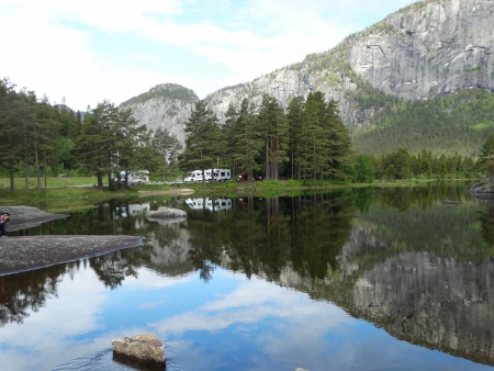
Our parking at Honnevje
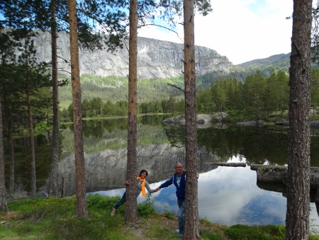
Wonderful place at the parking
Campsite : Parking Honnevje, Rv 9
4747 Valle, Aust Agder
DOING THE KVERNHUSVEGEN WALKING TRAIL
After exploring the beautiful parking area of Honnevje (believe me, there are lots to explore and photograph here), we drove down to the village of Valle. We went to the tourist office, which is also a beauty salon. We received two walking trails : one for Kvernhusvegen and another one for the Gloppefoss waterfall.
We decided to do the Kvernhusvegen trail, a 4.2 -km walk along scenic parts of Valle. We parked our camper before the school, which is the starting point of the trail. It was 11.30 when we began our walking trail. After walking about 300 meters, we arrived at Harstad, where we found a number of old black wooden houses, some of which served as watermills before.

At Harstad

The Tveitetunet farm in Valle
There were makeshift drainages made of wood that guided the waters down to the river. After that the next part became a bit difficult, as the path became steep, high and we had to walk on path with small stones and lots of wastes from sheeps. There were various fences which we had to open and close again so that the sheeps would not wander. Going up, we reached the Tveitetunet farmyard, which is a kind of museum. It was a property before of a former farmer and sheriff in the late 1890s. The old house, barn, and stable still stand up to this day. We then passed the Tveiten camping, where we took a short break; then we followed a concrete road all the way to Brottveit, all the time, having the scenic view of the valley below us, being the highest point of the walk with about 480 m above sea level.

Ideal place to stay fit.

The idyllic village of Valle
After about 2 km, we reached an old farmer’s road, a dirt road which led us then back to the starting point. We saw many interesting things along the way : a chainsaw which was just left on the road, an old beaten car parked elsewhere which served as storage for wood, wooden fences with sometimes a makeshift stairs, old abandoned troll houses, a barn whose roof was thickly covered with grass that even small plants begin to grow on top of it, some really beautiful houses and some not. There are also many wild plants around, varying from the colors of blue, violet, yellow, pink and white. It was a relaxed walk, that brought us to some idyllic spots in Valle. It was 13.30 when we returned to the camper. We drove back to Honnevje, had our well-deserved lunch of mushroom soup with boiled shrimps, and rested until 15.00
THE HIKE TO GLOPPEFOSS WATERFALL
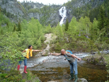
It was still early when we finished the first hike. Considering that we were not yet tired, we decided tos earch for the Gloppefoss waterfalls. This falls, which is more than 300 meters high, is one of the highest waterfalls in Setesdal valley, situated 9 kilometers away from the center of Valle. The hike is about 2-3 hours, covering a distance of about 6 kilometers.

The starting point of the hike to the waterfalls
The starting point is at a parking area at Rv 9. There were at least 5 other vehicles parked there when we arrived, and even spoke to a Dutch couple who just came back from the hike and informed us that the waterfalls could only be seen from a distance because it was impossible to get there because of the river. But we already knew beforehand that we have to cross the river , so we put on our rubber boots again. Armed with some fruits and a bottle of water, we began our hike. The first part of the hike was gradually going up via a gravel road, and then after about a kilometre, it was a tractor road. We felt it immediately in our legs that we were going high middle in the mountains. Left and right are high pine trees, many wild plants and ferns, some trees are beginning to grow again for the summer, and there were big boulders along the way.
After 30 minutes walk, we reached our first rest place. It was situated along the river Veiane, where a wooden bridge is placed to cross the river. There is a wooden picknick table and trash can. Crossing the river thru the wooden bridge, we then followed a steep dirt road/path, until we reached to a point that we had to cross the river again, but this time no bridge. The water was ice-cold; not too deep but flowing so hard. There were stones in the water, some big ones which we could step on. It looked dangerous because of the strong current of the waters and some treacherous deep areas in the river. Summoning up our courage, we tried to cross it, and we succeeded! The first obstacle had been overcome!

Impression of the hiking trail

Overcoming the first obstacle…
We continued our hike until we reached another part of the river again that we had to cross! Oh not again! Hardly recovering from the excitement from the first river crossing, we were again faced with another similar obstacle. After testing the waters, we opted not to do it anymore. At this point, the waterfall was already visible. We just contented ourselves with enjoying the scenery and taking pictures. We stayed there for about 20 minutes, then turned around to return.
Having some Kodak moments…
It was then that a young man appeared who crossed the first river barefoot! Getting some company and added motivation, we crossed the river together. It didn’t look so difficult after all. Walking about 100 meters, we had to cross again. It looked like the last time, so we did it again, fighting against the strong current and slippy stone-filled river. After that it was only a few meters away….and we were there! All our efforts were rewarded with the sight of the magnificent Gloppefoss waterfalls whose waters splash violently from a 300 meter height! It was an exhilerating experience seeing the waterfalls, especially when we think of how we got there, crossing the treacherous waters of the Veiane river. It was an experience difficult to forget! And we were glad we dared!

The mighty Gloppefoss waterfalls…

Happy to finish the hike 🙂
After about 15 minutes of admiring the beauty of the falls and taking some pictures, it was again time to go back. The river crossing was not so difficult anymore. There was a small postbox which contained a pen and notebook where the people can write their names in. And of course, we wrote ours also. The hike back is an easy one. Taking the same way, just following the river down the valley, we reached the parking area in just about 45 minutes. We then drove back to parking Honnevje, had a good dinner of paella and spent a relaxed evening, ending the day with a good drink!
